本文
Hiking Courses ハイキング
- Akechigoe Hiking Course 明智越えコース
- Ushimatsu Yama Hiking Course 牛松山ハイキングコース
- 7 Lucky Gods Pilgrimage of Tamba 丹波七福神めぐり
- Gyōja Yama/Tokonage Hiking Course 行者山・独鈷抛山ハイキング
- Hangokusan Hiking Course 半国山ハイキングコース
- Baigan Kodō Hiking Course 梅岩古道ハイキングコース
*Sometimes the hiking trails are closed due to mountain conditions. To find out if a trail is safe, please contact the Kameoka Tourism Association located in JR Kameoka Station Tel: 0771-22-0691.
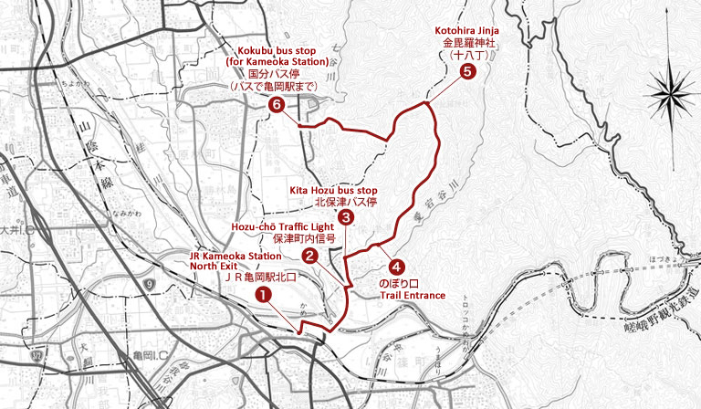
Akechigoe Hiking Course 明智越えコース
Length: 10 km
Time required: About 3 hours 30 minutes
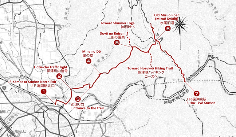
The Course
Starting at the (1) north exit of Kameoka Station, exit the station area and cross over the Hozu Bridge to get to the beginning of the hiking trail. Turn right when you reach the first intersection with a (2) traffic light. This small street should take you toward the mountains.
After passing Yōgenji temple (養源寺) and Bunkakuji temple (文覚寺) the road will fork, and you should follow the path to the right(3) (there should be a sign indicating the pathway to the hiking trail). After a few more minutes walking, this pathway will meet another road. Turn right at this T-junction. The entrance to the hiking trail will be behind a storage facility for a sake brewer (倉庫 sōko).
After climbing up the trail past (5) Doyō no reisen (土用の霊泉) you will see power lines and a fork in the road. Take the path on the right that leads down a mountain path.
This path will eventually turn and go up the mountainside. Follow this path until you reach another fork. Turn left toward Mizuo (水尾). The route leading to the right will take you to the Hozukyō Hiking Course (保津峡ハイキングコース). Keep walking until you reach the (6) Old Mizuo Road (水尾の旧道 mizuo no kyūdō). Turning left will lead to the village of Mizuō. Turning right will lead to (7) JR Hozukyō Station.
Points of Interest
Akechi Mitsuhide
During the tumultuous period of warring states, Akechi Mitsuhide was lord of Kameyama Castle. Akechi Mitsuhide was a military commander who served under Oda Nobunaga (1534-1582). Akechi Mitsuhide is famous for betraying Oda Nobunaga in favor of Toyotomi Hideyoshi. On May 26, 1582, Akechi Mitsuhide returned to his base, Kameyama Castle, and began preparing an army to protect Toyotomi Hideyoshi. On the 28th of May, he took what is now the Akechigoe Hiking Course path to Atago Shrine. There he penned a series of 100 poems known as the Atago Hyakuin. (Goe is taken from the Japanese word koeru, which means to go over. Therefore, the Akechigoe hiking trail is part of the road used by Akechi Mitsuhide to go over the mountain).
The Mizuo Yuzu Farm
If you follow the Old Mizuo Road (水尾旧道 mizuo kyūdō) to the left, you will reach the village of Mizuo. This region was especially beloved by Emperor Seiwa, the 56th emperor of Japan, and a special grave has been established in his honor. Famous for yuzu (a Japanese citrus fruit), depending on the season visitors can enjoy bathing in yuzu treated bathwater or chicken sukiyaki (reservations required). Some restaurants also provide transportation to JR Hozukyō Station.
Ushimatsu Yama Hiking Course 牛松山ハイキングコース
Length: 7 km
Time required: About 3 hours
The Course
Starting from the (1) north exit of JR Kameoka Station (JR亀岡駅北口), follow the street out of the station area and cross over the Hozu Bridge. Keep following this street until you reach an intersection with a (2) traffic light. Turn right at this intersection and follow the road past Hozu Elementary School (保津小学校 hozu shōgakkō) and the Post Office (保津郵便局 hozu yūbinkyoku). When you reach the (3) Kita Hozu (北保津) bus stop, turn right and follow the street toward the mountains. Just before the bamboo forest there will be a temple. At the back of the temple complex is a Shinto torii gate and a (4) stone stairway. Take these stairs to begin the mountain hike.
From here follow the indications along the path. If you stay on the widest path you will make your way back down to an area of Kameoka known as (6) Kokubu (国分).
Points of Interest
Ushimatsu Mountain (牛松山 ushimatsu yama)
At 636 meters tall, Ushimatsu Mountain towers over the northeast region of Kameoka. The northern side of the mountain offers a complete view of Kameoka and is a mounting location for ground-wave television broadcast equipment. On days when the fog is thick in Kameoka (late autumn and early spring), the top of Ushimatsu Mountain offers a stunning view of a sea of clouds.
Kotohira Jinja (金毘羅神社 kotohira jinja)
The Shinto god Kotohira protects those traveling by sea and oceanic transportation. However, Kameoka’s Kotohira Shrine specifically offers protection to those traveling on the Hozugawakudari River Boat Ride. The Hozu River begins its spring season on March 10th, which coincides with the festival day at Kotohira Shrine.
7 Lucky Gods Pilgrimage of Tamba 丹波七福神めぐり
See here for information on the 7 Lucky Gods Pilgrimage of Tamba.
Gyōja Yama/Tokonage Hiking Course 行者山・独鈷抛山ハイキング
Length: 10 km
Time Required: About 3 and a half hours

The Course
This course begins at (1)JR Chiyokawa Station (JR千代川駅). Exit the station from the west side and walk a little ways down the street that leads out of the station area. At the four-way intersection, cross Route 9 (国道9号線 kokudō kyū gōsen). Continue along the street running on the right side of (2)Chiyokawa Elementary School (千代川小学校 chiyokawa shōgakkō) and follow around the back of the school. Pass over the bridge and follow this street for a distance and you should reach the highway. Pass under the highway and when you reach a compound with (3) large water tanks there will be a pathway leading into the mountains. Follow this path to begin the hike.
Near the top of the mountain, there is (4) a large boulder that enshrines En no Gyōja, a bodhisattva (and it is a good place to take a short break). If you continue along the path you will reach (5) the top of Gyōjayama Mountain.
If you continue, you will come to a forest path. Follow this to the left and after about a ten minute walk you should arrive at (6) Senjuji temple (千手寺). From there, a narrow path leads down to (7) Hiedano Jinja shrine (薭田野神社). For the return trip, the (8) Kokudō Saeki (国道佐伯) bus stop is nearby.
Points of Interest
Tokonage Mountain Senjuji Temple (独鈷抛山 tokonagesan senjuji)
The many armed god Kōbō Daishi Yukari is enshrined at Senjyuji temple. This god is believed to have miraculous powers regarding eye disease and is often called the kannon of the eyes. It is said that washing one’s eyes with the sweet smelling water that bubbles out of the ground on this compound can bring relief from eye disease. April 17th and July 17th are designated as sennichi mairi (千日参), or days where visiting a certain temple is considered equivalent to visiting it 1,000 days in a row, so there are many visitors on these days.
Hiedano Jinja (薭田野神社 hiedano jinja)
It is believed that Hiedano Jinja shrine was built in 709 AD. The complex is studded with gnarly trees covered in bumps. It is believed that touching the bumps on these trees will ward off cancer. Originating in 826 as a ceremony to celebrate the arrival of special lanterns sent from the Imperial Palace in Kyoto, the shrine holds the Saeki Dōrō (佐伯灯龍ろ) every year to pray for a bountiful harvest. Along with the joruri puppet performances, this ceremony is a designated cultural treasure.
Other Routes on Tokonage Mountain
In addition to the route described above, there are other paths located on Tokonage Mountain. One path, known as the Kozaki Route, begins in Kozaki in Myazaki-chō (宮前町神前), passes by Hōrinji temple (宝林寺), and leads to Senjuji temple. Another path, known as the Okujō Route, begins in Okujō in Hiedano-chō (薭田野町奥条). This route passes by Zuiganji temple (瑞巌寺) on the way to Senjuji Temple.
Hangokusan Hiking Course 半国山ハイキングコース
Length: 12 km
Time required: About 4 hours
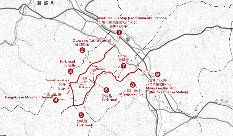
The Course
This course begins at (1) the Akakuma (赤熊) bus stop on the Keihan Kyoto Bus route 40 or the Kameoka Furusato Bus F43 line. After alighting the bus, follow the road you are on toward the mountains. The street should take you alongside a small river and past (2) a beautiful waterfall. Be careful while walking on the bare rock during the following 1 hour hike up the mountainside. You should reach (3) a fork in the road with a sign that points to (4) the summit of Hangokusan Mountain (半国山頂 hangoku sanchō).
On the way down, the road quickly splits into two paths (5). Take the left hand path and walk along the ridge. After a while, the road will split again (6). Take the path to the far right and continue on to Miyagawa (宮川). (The central path at this split is actually in the best condition, but it comes out in a village to the northwest of Miyagawa, which is where this hike ends)
Before reaching (7) Kinriji Temple (金輪寺) the path will dip into the forest. Feel free to stop in at Kinriji Temple. The path down to (8) Miyagawa Shrine (宮川神社 miyagawa jinja) passes in front of Kinriji Temple, and you can take it to continue your hike.
Keep following this path until you reach Miyagawa Shrine. After visiting the shrine, follow the path down to the street. Follow this until you reach a T-junction and turn right. Turn left at the first street you come to. The Miyazaki Post Office (宮前郵便局 miyazaki yūbinkyoku) is on the corner. Turn right at the post office and continue on until you reach the (9) Miyagawa (宮川) bus stop.
See the above links for bus information.
Points of Interest
Hangokusan Mountain (半国山)
Hangokusan mountain stands 744.2 meters tall in the western region of Kameoka. It gets its name from the view provided from the top of the mountain of half the Tamba country (Hangoku literally means half country). It is also known as the Mt. Fuji of Tamba. From the top of Hangokusan, one can look out over Atagosan, Arashiyama, Koshio, Ponponyama, Myōkenzan, and Rokkōsan Mountains, and if the sky is clear, the view stretches as far as Osaka Bay.
Kinriji Temple (金輪寺)
Kinriji temple is affiliated with the Tendai sect of Shugendō Buddhism built during the Kamakura Period of Japanese history (1185-1333). Kinriji Temple features a 5 tier pagoda characteristic of the Kamakura Period and has been designated as an Important Cultural Property. The forests surrounding this temple and the ruins of the Kannōsanjō mountain castle make the visit that much more worthwhile.
Baigan Kodō Hiking Course 梅岩古道ハイキングコース
Length: 11km
Time required: Approximately 3 hours
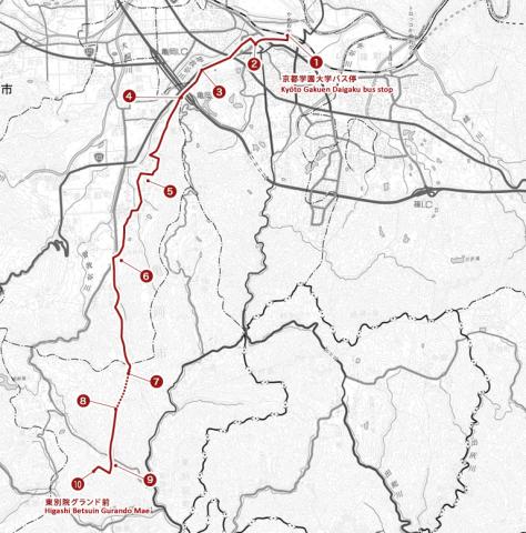
The Course
* Please note that part of the hiking trail (sakura tōge 桜峠 to chōjō 頂上) is closed from September 15~November 15.
*If you begin the course by taking the bus to Kyoto Gakuen University (京都学園大学 kyōto gakuen daigaku) it is 5 km long and takes approximately 2 hours to complete.
This course begins at (1) the south entrance of JR Kameoka Station. Exit the station and turn right onto Route 403 (the street running parallel in front of the station). Follow this until past one stop light and turn right at the (2) second stoplight (there should be a branch of Kyoto Bank (京都銀行 kyōto ginkō) on the corner. Before you reach an intersection with a stoplight, there will be a turnoff to your left. Turn left and follow this street until you reach the (3) Kazuka (加塚) intersection where Route 9 and Route 372 merge.
Cross Route 9 and continue west along Route 372. You should pass a traffic light blinking yellow and take your 4th left, which should take you behind a gift shop selling black beans called Mameya Kurobeiei (豆屋黒兵衛). When you reach the freeway, there will be an underground path that you can take to cross to the other side.
After crossing under (4) the freeway, continue straight for about 1 km until the road forks. Take the left-hand fork which will take you past a shrine and the Kyoto Gakuen University Ryūo Kaikan Meeting Hall (京都学園大学龍尾会館 gakuen daigaku ryūo kaikan). Continue until the street ends in a T-junction and you can see (5) Kyoto Gakuen University. Turn right and follow the street along the outside of the university grounds. Just past the bus terminal (round about) there will be a street where you can turn left. The street is surrounded on both sides by university buildings. Continue past the University gym (体育館 taiikukan).
You should come out onto a path along a river. Take a right and cross over the bridge. When the street ends in a T-junction, turn right. You should come to another river. After crossing the river, there will be an immediate T-junction. Turn left.
You will come around a corner and the street will slightly fork, with one branch going straight and one branch going left. Keep to the left and continue walking to Muryōji temple (無量寺). Continue along this path and you will come to (6) Okinō Shrine (興能神社). From there, follow the stone sign posts toward (7) Sakura Tōge (桜峠). Continue to (8) the top of the path toward (9) Shungenji temple (春現寺). You should see (10) Baigan Park (梅岩公園 baigan kōen) nearby.
The nearest bus stop is Higashibetsuin Gurando Mae (東別院グランド前) on the Kameoka Fursato Bus F22 and F23 lines. Very few buses pass through this area so please be sure to check the schedule before you depart.
Kameoka Furusato Bus Information (Japanese only)
Points of Interest
Kameoka is the birthplace of Ishida Baigan, who founded the religious movement known as Sekimon Shingaku. This hiking trail was created to celebrate the 280th anniversary of the founding of Sekimon Shingaku. This trail is open throughout the year (Except the pathway between Sakuratōge and Chōjō (the mountain top) which is closed every year from September 15 to November 15).